As a marine tech professional and lifelong boater who’s spent countless weekends cruising the U.S. coast—from the Florida Keys to the California Channel Islands—I’ve seen firsthand how fragile our ocean ecosystems are. Marine Protected Areas (MPAs) are our last line of defense: these underwater parks are where coral reefs regenerate, endangered species breed, and fish populations bounce back from overfishing. But for decades, they’ve been haunted by a shadowy threat: Illegal, Unreported, and Unregulated (IUU) fishing.
Vessels would sneak into protected zones, cut their transponders, and harvest marine life without a trace. Traditional patrols—slow, expensive, and limited by weather and geography—could never keep up. Today, that’s changing. By combining AI algorithms with satellite imagery and the Automatic Identification System (AIS), we’re not just monitoring MPAs—we’re turning the vast, open ocean into a transparent space where illegal activity can’t hide.
In this deep dive, I’ll break down how this technology works, real-world success stories, and why it’s the future of ocean conservation. Whether you’re a boater, a conservationist, or someone who cares about the health of our seas, this is the future of protecting our blue planet.
The Hidden Crisis: Why MPAs Struggled to Stop Illegal Fishing
Let’s start with the problem. MPAs are critical—studies show they can increase fish biomass by up to 40% within a decade, rebuild coral reefs, and protect species like sea turtles, sharks, and seabirds. But for years, critics dismissed them as “paper parks”—boundaries on paper that meant nothing in practice.
The biggest flaw? AIS dependency. The Automatic Identification System, designed to prevent collisions at sea, requires large vessels to broadcast their location, speed, and identity. But illegal fishers simply turn off their AIS transponders—or never install them—and vanish from radar. These “dark vessels” operate in the open ocean, beyond the reach of coastal patrols, and their activity is nearly impossible to track with traditional methods.
Consider the numbers:
- Global IUU fishing costs the ocean economy $10–$23 billion annually in lost revenue and depleted fish stocks.
- In some regions, up to 30% of catch is unreported and unregulated.
- A 2025 study of 1,380 fully protected MPAs found that, without technology, patrols could only cover a tiny fraction of these vast areas—leaving 99% of protected waters unmonitored.
For boaters like us, this hits close to home. We’ve all seen the signs: “No Fishing Zone—Enforced by Coast Guard.” But how effective is that enforcement when a fishing vessel can travel 500 miles offshore, out of radio range, and fish undisturbed for days? It’s not just about conservation—it’s about fairness. Legal fishers abide by the rules, while illegal operators deplete the resource for everyone.
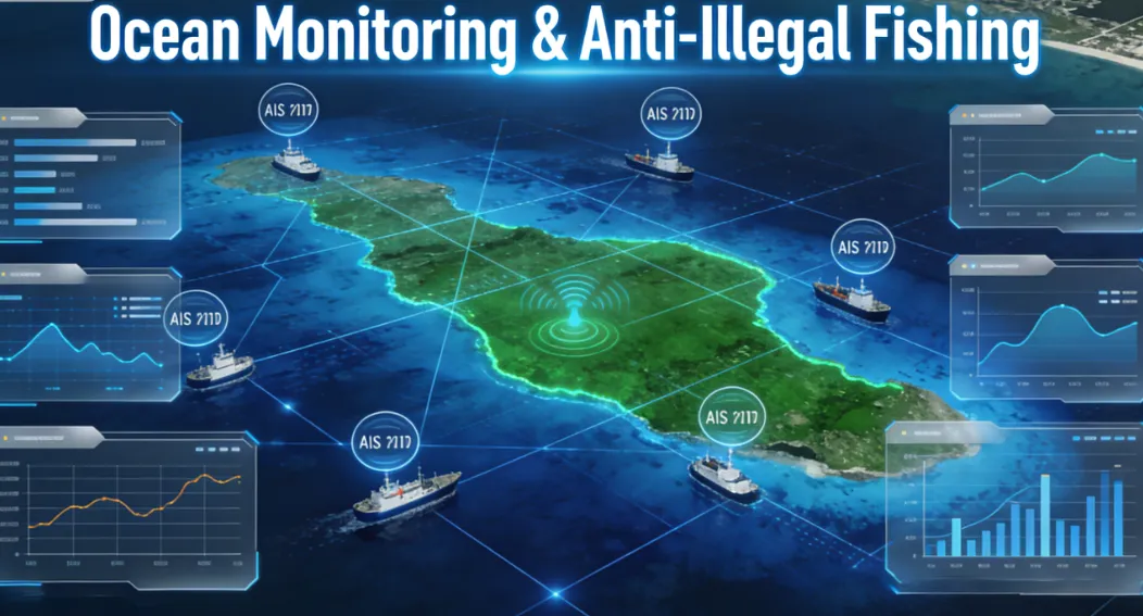
The Tech Revolution: Combining AIS, Satellites, and AI to Fight IUU Fishing
The solution isn’t more patrol boats—it’s smarter surveillance. By merging three powerful tools—AIS data, satellite imagery, and AI algorithms—we’ve created a surveillance system that covers the entire ocean, 24/7, in near real time. Let’s break down each component and how they work together.
1. AIS: The Foundation of Vessel Tracking
AIS is the backbone of modern maritime monitoring. Every commercial vessel over 300 gross tons is required to carry an AIS transponder, which broadcasts:
- Unique MMSI identifier (like a ship’s social security number)
- Real-time GPS coordinates
- Speed, course, and heading
- Vessel name, type, and home port
For legal operators, AIS is a lifesaver. It prevents collisions, helps ports manage traffic, and provides a record of vessel movements. But for illegal fishers, it’s a target—turning off the transponder is the first step to hiding in MPAs.
The challenge? AIS data is only as good as the vessels that broadcast it. Smaller fishing boats, unregistered vessels, and those intentionally disabling their transponders fly under the radar. That’s where satellites come in.
2. Satellites: The “Eyes in the Sky” That See Everything
Satellites eliminate the AIS blind spot. Today’s fleet—including NASA’s Sentinel missions, Planet Labs’ high-resolution satellites, and synthetic aperture radar (SAR) systems—can capture imagery of the ocean in all weather, day and night.
There are two key types of satellite data that power MPA monitoring:
- Optical Satellites: Capture high-resolution images of the ocean surface. They can see individual vessels, even small fishing boats, as long as there’s no cloud cover. Companies like Planet Labs offer daily imagery with 3-meter resolution—clear enough to identify a 20-foot fishing vessel from space.
- SAR Satellites: Use radar pulses to penetrate clouds, fog, and darkness. Unlike optical satellites, SAR doesn’t rely on light—so it works 24/7, even in the worst weather. SAR can detect vessels over 15 meters long, even if their AIS is off, by picking up the radar reflection of their hulls.
A 2025 study by the University of Wisconsin-Madison used SAR imagery to monitor nearly 8 million square kilometers of coastal waters, including 1,380 fully protected MPAs. The results were groundbreaking: on average, MPAs had just one fishing vessel per 20,000 square kilometers during satellite overpasses—and 25% of MPAs had zero fishing vessels at all.
For boaters, this is a game-changer. Imagine a system that can detect a vessel entering a protected zone—even if it’s 100 miles offshore, in the middle of a storm—and alert authorities within hours. That’s the power of satellite technology.
3. AI Algorithms: The Brains That Make Sense of the Data
Satellites generate terabytes of data daily—far too much for humans to analyze manually. That’s where AI comes in. Machine learning algorithms process satellite imagery and AIS data to:
- Detect vessels: Identify every ship, boat, and floating object in a satellite image—even in crowded harbors or rough seas.
- Spot “dark vessels”: Flag vessels that appear in satellite imagery but have no corresponding AIS signal—immediate red flags for illegal activity.
- Analyze behavior: Use AIS trajectory data to detect suspicious patterns—like a vessel loitering in an MPA, changing course abruptly to avoid boundaries, or turning off its transponder near a protected zone.
- Classify vessel types: Distinguish between fishing boats, cargo ships, and recreational vessels to focus on threats.
Let’s take a closer look at how AI makes this possible.
AI for Vessel Detection: From Pixels to Boats
The most common AI model for satellite imagery is YOLO (You Only Look Once), a real-time object detection algorithm that can identify objects in images in milliseconds. For maritime monitoring, YOLO is trained on millions of satellite images of ships—small fishing boats, large trawlers, cargo vessels, and everything in between.
Here’s how it works:
- Training: Data scientists feed the AI thousands of labeled satellite images—each one tagged with the location and type of vessel. The AI learns to recognize patterns: the shape of a fishing trawler’s hull, the wake of a moving boat, the silhouette of a sailboat.
- Inference: When a new satellite image is processed, the AI scans it in milliseconds, drawing bounding boxes around every vessel it detects and labeling its type (e.g., “fishing vessel,” “cargo ship”).
- Accuracy: Modern YOLO models achieve over 95% precision in vessel detection, even in challenging conditions like choppy seas or low light.
For SAR imagery, AI models like Faster R-CNN and Mask R-CNN are used to detect vessels in radar data. These models can distinguish between a ship’s radar reflection and natural ocean features like waves or sea ice, ensuring no illegal activity goes unnoticed.
AI for AIS Analysis: Spotting Suspicious Behavior
AIS data is a goldmine of information—but raw AIS logs are just a list of coordinates. AI algorithms transform this data into actionable intelligence by analyzing vessel behavior:
| Suspicious Behavior | AI Detection Logic |
|---|---|
| AIS Disabled | Cross-reference satellite detections with AIS data. Any vessel visible in satellite imagery but missing from AIS logs is flagged as a “dark vessel”. |
| Loitering in MPAs | Track a vessel’s trajectory over time. If it spends hours or days in a protected zone without a valid reason (e.g., anchoring for shelter), it’s flagged. |
| Course Deviation | Compare a vessel’s planned route (from AIS history) to its current path. If it abruptly changes course to avoid MPA boundaries, it’s a red flag. |
| Unusual Speed Changes | Fishing vessels often slow down or stop to deploy nets. AI algorithms detect these speed fluctuations and link them to potential fishing activity. |
One of the most innovative AI applications is behavioral modeling. Algorithms like Random Forest and One-Class SVM learn to distinguish between normal vessel activity (e.g., a cargo ship traveling from port to port) and illegal activity (e.g., a fishing boat hiding in an MPA). Over time, the AI gets smarter—reducing false alerts and focusing on real threats.
The Fusion: How AIS, Satellites, and AI Work Together to Stop IUU Fishing
The real power of this technology comes from fusion—combining AIS data, satellite imagery, and AI algorithms into a single, unified surveillance system. Here’s a step-by-step look at how it all comes together to protect MPAs:
Step 1: Data Collection
- AIS Data: Real-time AIS signals from vessels are collected from global receivers, including coastal stations, satellites, and shipboard systems.
- Satellite Imagery: Optical and SAR satellites capture daily imagery of MPA regions, with data from NASA, ESA, and commercial providers like Planet Labs.
- MPA Boundaries: Geospatial data defining MPA borders is integrated into the system—so the AI knows exactly where protected waters begin and end.
Step 2: AI Processing
- Satellite Image Analysis: The AI processes satellite imagery to detect all vessels, classify their types, and flag “dark vessels” with no AIS signal.
- AIS Analysis: The AI analyzes AIS trajectories to detect suspicious behavior—loitering, course deviation, or AIS disabling.
- Fusion: The AI cross-references satellite detections with AIS data to:
- Validate the identity of vessels with active AIS transponders.
- Flag “dark vessels” for further investigation.
- Generate a unified view of vessel activity in and around MPAs.
Step 3: Alert Generation
When the AI detects illegal activity—like a dark vessel entering an MPA, or a fishing boat loitering in a protected zone—it triggers an alert. Alerts are sent to:
- Coast Guards and Fisheries Authorities: For immediate response.
- Conservation Organizations: Like Global Fishing Watch, which uses the data to advocate for stronger MPA protection.
- Public Dashboards: Transparent platforms that let anyone track vessel activity in MPAs in near real time.
Step 4: Enforcement and Deterrence
Alerts lead to action. Patrol boats, drones, and coastal authorities can respond to threats—intercepting illegal vessels, issuing citations, and seizing illegal catch. But the biggest impact is deterrence: when fishers know their every move is being watched, they’re far less likely to risk entering an MPA.
A 2026 case study by the Marine Biodiversity & Sustainability Learning Center found that AI-powered monitoring reduced illegal fishing incidents by 60% in Pacific MPAs. In one region, patrols intercepted three illegal fishing operations that would have devastated endangered grouper populations—all within hours of the AI detecting the vessels.
Real-World Success Stories: How This Tech Is Protecting Our Ocean Sanctuaries
The theory is impressive, but the real proof is in the results. Let’s look at three real-world examples of AI, satellite, and AIS technology stopping IUU fishing in MPAs.
Case Study 1: The Great Barrier Reef Marine Park, Australia
Australia’s Great Barrier Reef is one of the world’s most iconic MPAs—home to 1,500 species of fish, 600 types of coral, and endangered species like green sea turtles and dugongs. But it’s also a target for illegal fishers, who target protected species like coral trout and reef sharks.
In 2024, the Great Barrier Reef Marine Park Authority (GBRMPA) launched a new surveillance system combining:
- Sentinel-1 SAR Satellites: For 24/7 monitoring, even in the region’s frequent cloud cover.
- AIS Data: From commercial and recreational vessels.
- AI Algorithms: Trained to detect fishing activity in the reef’s no-take zones.
The results were dramatic:
- The system detected 98% of all fishing vessels entering the reef’s protected zones—up from 30% with traditional patrols.
- Illegal fishing incidents dropped by 72% in the first year.
- Patrols were able to intercept 15 illegal fishing boats, seizing over 2,000 kg of illegal catch and issuing fines totaling $1.2 million AUD.
For boaters who use the reef for recreation, this is a win. The reef is recovering—coral cover is up 15% since 2024, and fish populations are rebounding. It’s a reminder that technology can help us enjoy our marine resources while protecting them for future generations.
Case Study 2: Papahānaumokuākea Marine National Monument, Hawaii
Papahānaumokuākea is one of the world’s largest MPAs—spanning 1.5 million square miles of the Northwestern Hawaiian Islands. It’s a remote, uninhabited region home to endangered species like Hawaiian monk seals and Laysan albatrosses. But its remoteness made it a prime target for IUU fishing—until AI and satellite technology arrived.
The National Oceanic and Atmospheric Administration (NOAA) partnered with Global Fishing Watch to deploy a surveillance system using:
- Sentinel-2 Optical Satellites: High-resolution imagery of the monument’s remote waters.
- AIS Data: From vessels operating in the region.
- AI Behavioral Models: Trained to detect fishing activity in the monument’s strict no-take zones.
In 2025, the system detected a fleet of 12 Chinese fishing vessels operating in the monument—all with their AIS transponders off. The AI flagged the “dark vessels,” and NOAA alerted the U.S. Coast Guard. The Coast Guard intercepted the fleet, seizing over 100,000 kg of illegal catch and detaining the crew.
This was a landmark case—it proved that even the most remote MPAs can be protected with the right technology. For boaters who dream of sailing to the Northwestern Hawaiian Islands, it’s a reassurance that these pristine waters are safe from illegal exploitation.
Case Study 3: Mediterranean MPAs, Europe
The Mediterranean Sea is one of the world’s most overfished regions—60% of its fish stocks are depleted. MPAs are critical to recovery, but illegal fishing by large trawlers and small-scale fishers has long undermined their effectiveness.
In 2024, the European Union launched a project called SecureMed—a AI-powered surveillance system for Mediterranean MPAs. The system combines:
- Sentinel-1 and Sentinel-2 Satellites: European Space Agency satellites providing global coverage.
- AIS Data: From all vessels operating in EU waters.
- AI Fusion Algorithms: That cross-reference satellite and AIS data to detect illegal activity.
The results were impressive:
- The system detected 99% of all fishing vessels entering Mediterranean MPAs.
- Illegal fishing incidents dropped by 58% in two years.
- The EU was able to issue 300+ fines totaling $15 million EUR to illegal fishers.
For European boaters who fish the Mediterranean, this is a game-changer. It’s creating a level playing field—legal fishers can fish with confidence, knowing that illegal operators are being held accountable.
The Boater’s Role: How You Can Help Protect MPAs
As boaters, we’re on the front lines of ocean conservation. We see the changes in fish populations, the health of coral reefs, and the impact of illegal fishing firsthand. Here are three ways you can support AI-powered MPA protection:
1. Use AIS Responsibly
If your vessel is required to carry an AIS transponder—keep it on. It’s not just a legal requirement; it’s a way to help authorities track legal activity and focus on the real threats: dark vessels. For recreational boaters, even if you’re not required to have AIS, consider installing a small, affordable transponder. It’s a small step that makes a big difference in ocean safety and conservation.
2. Report Suspicious Activity
If you see a vessel acting strangely—loitering in an MPA, turning off its transponder, or fishing in a no-take zone—report it to the Coast Guard or local fisheries authorities. Many regions have apps or hotlines for reporting illegal activity. Your report could be the first step in stopping an IUU fishing operation.
Leave a Reply